** DISCLAIMER: Many of the routes listed on the website are Black to Double Black Diamond; please use Extreme Caution when picking a ride and then taking it on. – You Assume Your Own Risk when using this website’s information. Do Not Ride Alone; Cell Service is Spotty in some locations. All these routes are for people who are fit and in shape, with expert skills in high-altitude riding, water & hydration, food, tools, and knowledge to repair a bike. It’s on you if you take any of these rides; you Assume ALL RISK!
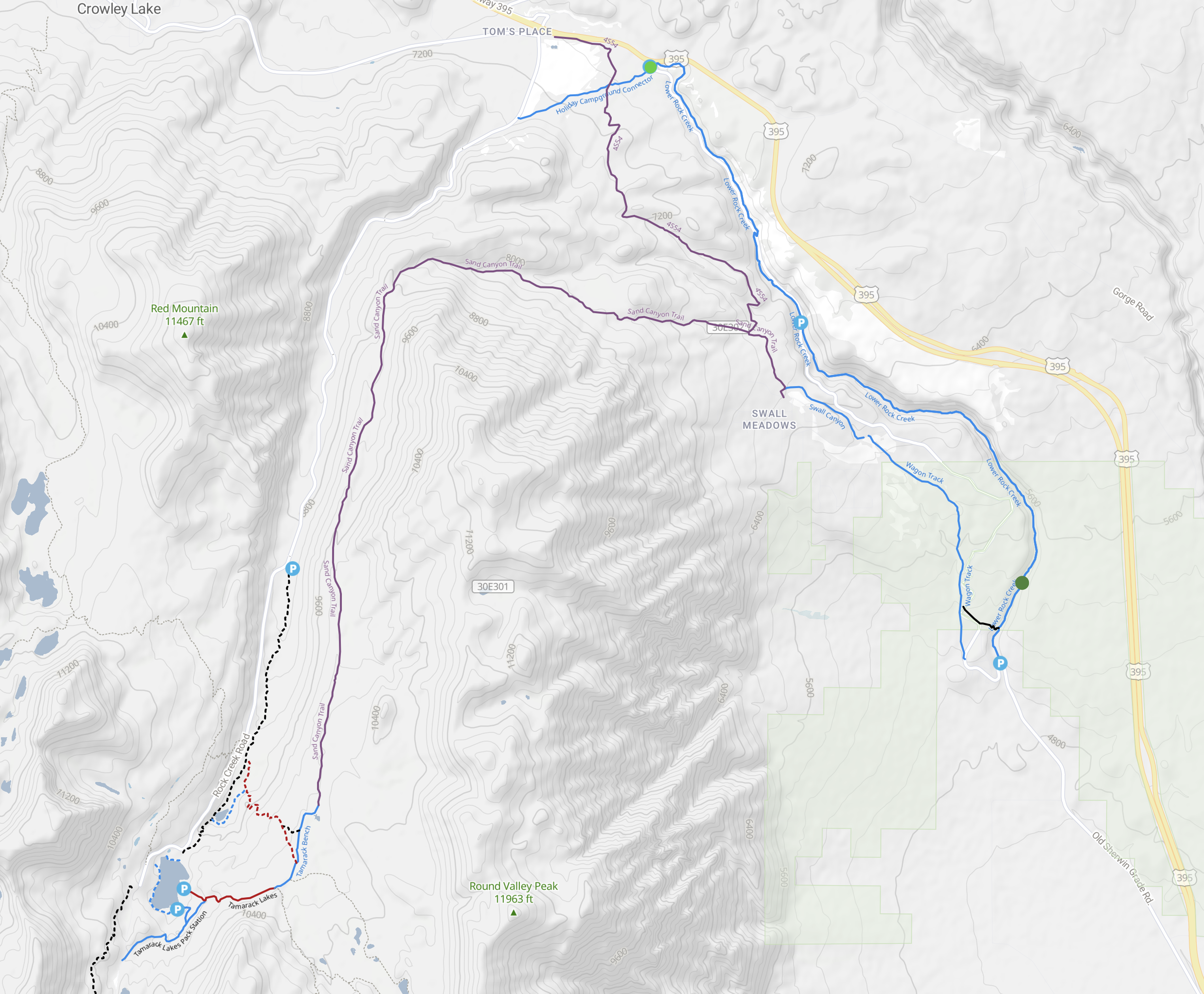
Lower Rock Creek Canyon: This Trail is an old classic for Mountain Bikers. The route is 8 miles long, with the top half running through a lush forested creek with many full-grown Aspen Trees added to the creek side. The lower half runs you into a more high desert terrain as you leave the forest near the start of lower section 3.
The ride down the canyon is 8 miles long, and there are three different sections of the trail you ride. All of those sections are single-track trails. The top 2 sections contain intermediate downhill and climbing action with nice flowing turns.
The dirt is mostly firm, with just a few soft sections. You do have to watch out for the creek in section 2, as there are two turns where it’s easy to go into the water if you’re not careful.
Section 3, the lower section, is a ton of fun, but there will be many hike-a-bike moments for many riders. This is also the longest section at over 4.5 miles long. We advise advanced and expert riders only in the lower section 3.
If you want to do this ride as a loop, park at Paradise and then ride up the 1850+ vertical feet to the start. Most people like to warm up on the first section of the paved road and take in the killer views, then ride up the single trail on the upper two sections. No matter what, it’s a good workout with the added fact that you’re riding above the 5000-foot level in elevation.
This is a shared-use trail, so you must watch for hikers, dogs, and downhill mountain bike bombers. You will also encounter people using this trail for their fishing adventure, so watch out for fishing poles and hooks.
Directions: You can park at the trailhead at the top, bottom, or mid-canyon. Many people will do their own shuttle to the top, leaving a car at Toms Place.
E-MTBs: Lower Rock Creek Trail is a USFS non-motorized trail, so E-Bikes are prohibited and can be ticketed.
Stats & Details: Trail Length 7.9 miles Out and Back, 6000-4500′ elevation, 98% single track, Hard effort uphill, Intermediate downhill top two sections with advanced to expert for the lowest section of Trail. There is a road crossing at the end of each of the three sections.
MTN Bike Project Link: https://www.mtbproject.com/trail/4914078/lower-rock-creek-trail
Sunny Slopes / Upper Gorge Loop: This ride starts at Tom Place and uses the 395 access tunnel to get you over to Sunny Slopes, where you see all the homes. You then ride the pavement under a mile, and then you will be on dirt forest services roads down to the Crowley Lake Dam. The roads in the area are a mix of packed dirt with some loose, soft, and sandy sections during dry times and over the summer months.
Just up from the dam, you end up on a gorgeous single/double track section that runs 1.1 miles along the upper Owens River Gorge. Being in the gorge is impressive, even if it’s only for a mile. There is a lot of wildlife here, along with amazing views.
The last part of the route is back on Forest Service Roads, which will take you back to the tunnel under 395 and then to Toms Place. You get lovely views of the Sierra and Rock Creek Canyon during the ride.
The best time to ride here is in the Spring or after Summer Thunder showers move through the area. Fall rides can be nice once the ground gets a good dose of rain or a dusting of snow. During winter, there are many years that this area does not get deep snow, and you can ride out here mid-day layered up without freezing.
Local Tip: This 11-mile mountain bike loop is best made when the ground is not dry and sandy. We are going to try out E-MTBs in this area soon and see how they do in the soft dirt mid-summer conditions and will report back.
Directions: Park just past Toms Place on the right side of Crowley Lake Drive. A dirt road about 50 yards or so up from Toms leads to the tunnel that goes under 395. If you’re staying in Bishop, Toms Place is a 25-minute drive to the north. If you’re coming down from Mammoth Lakes, it’s about a 20-minute drive.
E-MTBs: Yes, they are allowed.
Stats: Trail Length 10.9 miles Loop, 7,197′ to 6,654′ Elevation, 20% Single / Double Track, 80% Forest Service Dirt Road, Moderate Effort unless it’s hot and sandy mid-summer,
MTN Bike Project Link: https://www.mtbproject.com/trail/7006150/owens-gorge-loop
Toms Place Forest Road 4S54: This Forest Service dirt road provides excellent views and a fun little workout out of Toms Place. This route is full width to double track and is 8.6 Miles Out and Back, with around 1400 feet of climbing. The ride starts with a bit of a mellow downhill grade, climbs 500 feet, and then descends over 800 vertical feet.
This a very scenic double-track route that can be taken on a Mountain Bike or a Mountain E-Bike. The double track is mellow and great for a cruise and will get your lungs pumping. When you hit the 4.3-mile mark, the route hooks up with Sand Canyon Road; for those on E-MTBs, you can continue up into San Canyon and up to the Wheeler Ridge route.
You would have to hike a bike through some thick rock sections to get to the top of Sand Canyon. So, it’s not advised unless you are incredibly fit to carry your bike through those sections.
Directions: Park at Toms Place and then ride Crowley Lake Drive south past the 395 exit to Toms. There is a right turn to the small power plant just down the road. Take the right turn, and then on your immediate left and well marked is Forest Service Road 4S54.
E-MTBs: Allowed
Stats: Length 8.6 Miles Out and back, 4.3 Miles to Sand Canyon Road / 6,561 ft to 7,377 ft. Elevation / 100% Forest Service Dirt Road / Moderate to Hard Effort
Trail Forks Link: https://www.trailforks.com/trails/4s54/
Holiday Campground Connector Trail: This short little Trail is a great way to reach the Lower Rock Creek Mountain Bike Trail. From the Campground, the ride is 2.6 miles out and back with a drop of 438 vertical feet down to Lower Rock Creek Trail Junction. Just beware, it’s all uphill back to the Campground or Toms Place.
E-MTBs: They are not legal to ride on this trail.
Directions: You can access the Lower Rock Creek Trail via the shared-use connector trail from the Holiday Campground. If you’re starting from Tom Place, you can ride down 4S54 for a bit and then take a left on the connector trail to access Lower Rock Creek Trail.
Trail Forks Link: https://www.trailforks.com/trails/holiday-campground-connector/
Upper Rock Creek Canyon Trail: This single-track trail winds through open areas, creekside beaches, picnic areas, and some campgrounds. The views here are all time and will leave you stunned and feeling great. Plan on stopping at the creek side, relaxing, and, of course, taking some photos.
Starting at the Snopark parking area, this highly shared-use trail follows a path along Rock Creek out and back for 6 miles. From the start, the trail heads uphill with a total vertical over 3 miles of around 850 feet. While the trail is smooth and not too hard to ride in most spots, you need to be in good shape as it gets steep for a bit on this ride.
Local Tip: This is a mixed-use trail with many people due to the trail running through a couple of campgrounds and people fishing Rock Creek. This is not your trail if you’re looking for a fast downhill.
Directions: Take Rock Creek Road up 5 miles from Toms Place and then take a left at the signed Sno Park Parking area. You will see the trailhead at the back side of the parking area. It’s easy to see you can’t miss it.
E-MTBs: They are not legal to ride on this trail.
Stats: Length 6 Miles Out and Back/ 8,884 ft to 9,707 ft. Elevation / 100% Forest Service Single Track / Moderate to Hard Effort
Trail Forks Link: https://www.trailforks.com/trails/upper-rock-creek-canyon/
Sand Canyon Mountain Bike Trail: This adventure ride is a fantastic route for hard-core expert riders. You go from the high country at 10,000 feet down into the upper desert regions of the Lower Rock Creek Canyon.
The ride starts with a steep climb with several hike-a-bike sections right from the back side of Rock Creek Lake. Once you get up that first climb, the ride is 4,000 feet of primarily downhill action with just a couple of climbs mixed in on the descent. The downhill action combines Single / Double Track and OHV road action.
There are several challenging rock garden sections that you want to take caution in on the descent. You will also find some very soft and sandy areas during the driest time of year, so be ready for some loose stuff. Sand Canyon will land you smack dab out in the middle of no man’s land.
This is back county without being in the wilderness. You must be self-sufficient on this route with water, food, bike repair knowledge, spare tubes, and the tools to fix a problem.
This is a shared-use OHV trail and is also used to drive horses and mules up the Rock Creek Pack Station in the early Summer and then back down again in the Fall.
Local Tip: The best time of year to take this ride is during the Fall after the first rains or dusting of snow has melted off and the trees are changing and all lit up in Yellow.
Directions:
E-MTBs: This route follows an OHV road, so E-Bikes are allowed. I plan to try to ride a Turbo Levo up this route soon and will report back on how it goes and how far I can make it.
Stats: Trail Length is 7.9 miles from Rock Creek to the bottom or 16 miles out and back from Sunny Slopes, 10,250-6500′ elevation spread, 98% double track, Hard effort up and down; this trail is for Expert Riders only.
MTN Bike Project Link: https://www.mtbproject.com/trail/7003506/sand-canyon-trail
Wheeler Crest Road #30E301: This route takes you up an old and very rough 4 x 4 OHV route to the top of Wheeler Crest. The view at the top is all-time and stretches out to Bishop and over to the White Mountain. Behind you is the Sierra Crest. This is a worthy route to add to your mountain bike ride down Sand Canyon if you’re extra fit.
Directions: Take a venture off the Sand Canyon Trail and ride up to the top of Wheeler Crest Road #30E301.
E-MTBs: This route follows an OHV road, so E-Bikes are allowed. I plan to try to ride a Turbo Levo up this route soon and will report back on how it goes.
Stats:
MTN Bike Project Link: Nobody has yet to run a GPS this route on MTB Project or Single Tracks.
Wagon Wheel: This is a short but fun 2-mile downhill trail located near Lower Rock Creek Canyon Trail. The trailhead is about a quarter mile from Sand Canyon Road. The trail drops about 925 feet over 2 miles. There is a mix of terrain, with chunky trails, rock gardens, and more open sections.
Directions: Located down Lower Rock Creek Road on Swall Meadows Rd. About .15 miles in.
E-MTBs: They are not legal to ride on this trail.
MTN Bike Project Link: https://www.mtbproject.com/trail/7003505/wagon-wheel-trail