Bishop, California, is an excellent place to visit if you’re into Mountain Biking or the New Generation E-MTBs. I live here and ride out my front door to hit the dirt every other day.
What you will find in the Bishop area is miles of terrain that includes single-track trails, dirt roads, and OHV terrain in the foothill areas and along the Owens River.
Higher up, you can ride single-track trails and double tracks in Bishop Creek Canyon, Coyote Flats, and Pine Creek Canyon. To the east, you get the White Mountains, the Poleta OHV area, and the famous Silver Canyon area.
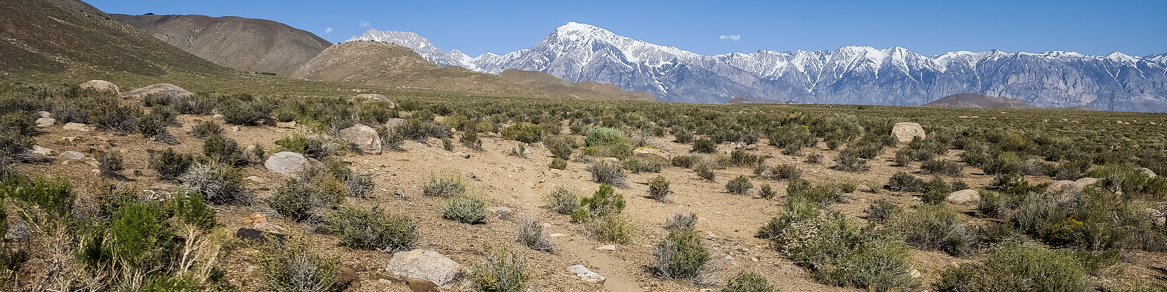
While riding here, you are treated to some very amazing views with multiple 13,000 to 14,000 peaks to Bishop’s east and west sides. It is pretty stunning to take it all in.
The small town of Bishop is located at the northern end of the Owens Valley at 4100 feet in elevation. The weather is mild and perfect in the mid to late spring and during the Fall months.
Winter riding is great mid-day under the sun, with highs in the 40s and 50s. Just make sure you layer up correctly. This area has few snow days during most winters, allowing you to ride daily all year.
Summer in Bishop is downright hot, with early morning rides mandatory, or forget it. When the heat is on, we advise starting your ride by 7:30 AM or heading to one of the preferred high-country routes if you’re a late riser.
Videos: Below is a playlist of mostly older YouTube Videos from the Bishop Area. Over the next six months, we plan to re-ride all these areas and get fresh videos and photos that will be posted here ASAP.
For now, some of the videos below give you an idea of how intense some of the trails we have here are. FYI: E-Bikes do great outside of Bishop for long, long rides.
Here is the list of Mountain Bike Rides near Bishop, California:
** DISCLAIMER: Many routes below are Black to Double Black Diamond; use Extreme Caution – Assume Your Own Risk. Do Not Ride Alone; Cell Service is Spotty in some locations. All these routes are for highly fit and skilled Mountain Bikers with expert skills in altitude riding, water & hydration, food, tools, and knowledge to repair a bike. It’s on you if you take any of these rides; You Assume ALL RISK!
West Bishop Foothills near Bir Rd: There is a vast network of dirt roads, double tracks, and single-track trails in the foothills outside West Bishop. This ridable network extends to Wilkerson, where the Rawson Creek Route emerges.
The maze of trails can be a bit confusing at first, but every route leads to a most enjoyable mountain bike ride. The foothills in the area generally have a rise of 600 – 1000 feet.
Use this link to learn more about Mountain Biking riding in the West Bishop area, including a Map.
Lower Poleta Hills: At the end of West Line Street, about a mile past the Owens River, you will find the Poleta Canyon Foothills OHV area. The views here are amazing as you look from the White Mountain Foothills to Bishop and over to the Sierra Crest.
This area has a ton of OHV Trails along with some fun single-track routes. You can see some of the trails on Google Maps. The climbs in the area are moderate to strenuous but a ton of fun for those who are fit. E-bikes are also welcome here.
Beware Tip: The season to ride here is mid-September – mid-May. After that, it gets deadly hot fast from about 10 AM into the overnight hours.
Directions: Take East Line Street to the Owens River; about 1 mile beyond that, you will come to a big right and turn in the road. At that point, you’re at the large dirt parking area at the base of the Poleta Canyon OHV area.
E-MTB: Are allowed in this area OHV area.
Black Rock Canyon Climb: Block Rock Canyon is worth trying if you’re looking for a brutal kick-your-but dirt road climb. Expect some hike-a-bike sections after the 2023 extreme winter. This climb will take you 10 miles up Black Rock Canyon.
If you make it up the climb, you get the joy of riding down the 10-mile Poleta Ridge Downhill back to the starting point. If you’re considering this loop, you must be self-sufficient and have a well-tuned bike, tubes, and lots of water and carbs.
Beware Tip: The road and trail have some washed-out sections that you will need to hike a bike and, in some areas, carry your bike over the rocks. Hopefully, at some point this year, the forest service will get in there and clean up the mess and re-grade the road.
E-MTB: Are allowed in this area
Directions:
Stats: Length 10+ Miles, 4100 – 9,100+ elevation, OHV Dirt Road, Medium to Expert Technicality, Hard effort to Extreme Effort
Poleta Canyon Downhill: This is a classic old-style moto cross single-track trail. The route goes for 10 miles and wraps from the pines of the high country down into the desert sage.
You will encounter everything from smooth and flat to steep and rocky sections. There are a couple of areas that some might want to walk through. The views from the trail are inspiring, and you’ll want to stop and get some photos in.
Getting here is challenging as you must climb up the 10-mile black mountain road or get a shuttle ride up the white mountain road and work your way down to the trailhead.
Beware Tip: Expert to Pro Mountain Bikers Only – This ride is very inaccessible, so take it easy; help is a long way off. Better know how to fix your bike and be competent to carry lots more water and food than you think you need.
Directions: To access the traditional way to reach the top trailhead is to ride the 10 miles of Black Rock Canyon Road. You can also get a Shuttle up White Mountain Road, come down Black Canyon Trail, and link into Poleta Canyon. Use the MTN Bike Project GPS App to help map this out.
E-MTB: Are allowed in this area
Stats: Length 10+ Miles, 5000 Vertical Feet Downhill, Moto Cross Single Track & OHV Dirt Road, Expert Technicality, Hard Effort
Papoose Flat Loop: is a long, isolated ride outside Big Pine. Just up the Asgard pass about 3 miles from town. This one has a long slog of sand that you will want to hike a bike through, but it’s still worth the adventure and the fantastic view of the Owens Valley into the Southern Sierra.
This ride requires self-sufficient riders who are well-fit and can fix gear on the trail side. This ride needs extra water and carbs and is at a high elevation. More Details on this ride are Coming Soon.
Tip:
Directions:
E-MTB:
Stats:
MTN Bike Project Link:
Bishop Creek Canyon / Coyote Flats Area / Pine Creek Area
** DISCLAIMER 2: Most of these routes are on double-track / OHV roads at extremely high elevations. It’s on you if you take any of these rides; you assume ALL RISK!