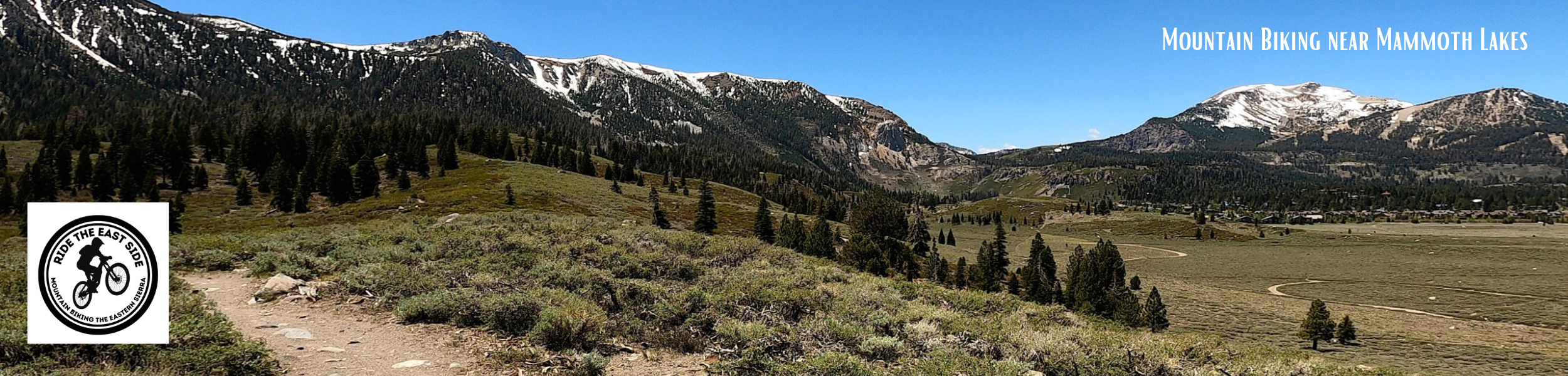
USFS Mountain Biking near Mammoth Lakes
Here is a list of the Mountain Bike Trails and Forest Service roads you can ride near the Mammoth Lakes Area. Since 1985, these have been the go-to routes that I hit right from the front door of my home in Mammoth.
Local Tip: The best way to ride up here is to create loops and routes mixing in the numerous trails, dirt road routes, and paved trail system I list below.
This is Neverland, so use your imagination and make a great loop to go out and ride.
** DISCLAIMER: Many of the routes listed on the website are Black to Double Black Diamond; please use Extreme Caution when picking a ride and then taking it on. – You Assume Your Own Risk when using this website’s information. Do Not Ride Alone; Cell Service is Spotty in some locations. All these routes are for people who are fit and in shape, along with being a skilled Mountain Biker with expert skills in altitude riding, water & hydration, food, tools, and knowledge to repair a bike. It’s on you if you take any of these rides; you Assume ALL RISK!
#1 Mountain View Trail: This Trail is one of the top mountain bike rides in the Inyo National Forest. The route takes a series of single-track sections mixed in with old forest service roads that lead up to the Minaret Vista.
Along the way, you get forested areas, open spots with long-range views, and green and flowery mountain meadow sections. When you reach the Visit Point, you will be treated to some epic views of Ritter, Banner Peaks, and the Minarets. You will also get a great view of Mammoth Mountain.
The Minaret Vista area has picnic benches and bathrooms, making this a great lunch stop and photo-op area.
The route has a total ridable vertical rise of around 780 feet with a starting elevation of 8500 feet and a peak elevation of 9155 feet at the Minaret Vista Scenic Area.
This route features cross-country-style riding with some decent hill climbing. As for skill level, this one is for advanced-level cross-country mountain biking riders. You must also be in great shape and be capable of riding a 10-mile loop at high elevations.
The downhill ride back down Mountain View is a total blast. However, I prefer to ride up Mountain View and then link with the Mountain View connector trail into the Mountain Bike Park.
For those with bike park passes or peddle passes, you ride 1/2 mile down Minaret Vista Road and access the park from the Mountain View Connector Trail right by the Reds Meadow Entrance Station.
And Yes, you need at least a Bike Park Peddle Pass to enter the park. The Mountain has staff out checking to ensure people have ride tickets.
Directions: Living in Mammoth, this was an out-the-door ride for us, taking the Uptown Trail from the Village to the junction with the Mammoth Earth Quake Fault connector Trail and then right into the Mountain View Trail and up to the Minaret Vista.
Go to the Mammoth Earthquake Fault parking lot to ride Mountain View Trail from the Trailhead. A trailhead sign is right by the parking lot bathroom shed to the left. This parking area is located about 3 miles out of Mammoth Lakes on the road to the Ski Area Main Lodge, Highway 203.
Local Tip: This is one challenging route due to altitude and is not advised as a family ride unless you’re all hardcore riders in great shape.
E-Bikes: Mountain View is a non-motorized USFS trail, so E-bikes are not allowed, and you can be ticketed at a minimum.
Stats: Length – 11 miles out and back, 8,500-9,130 elevation levels, 75% single track, Medium to Hard Technicality with a Hard effort
#2 Mammoth Rock Trail: This is one of the original Mountain Bike rides that people have been riding here in Mammoth Lakes since the early ’80s. While the Trail is fun to ride, the views here are king with Mammoth Lakes, Old Mammoth, Mammoth Mountain, Long Valley, and the White Mountains.
The Trail is shared with hikers and horses and runs from near the top of Old Mammoth Road down under Mammoth Rock and then down across the face of the Sherwin Range and into the lower parts of town.
Being right under the Mammoth Rock formation is an incredible sight; you will want to stop and get some photos. About a mile down the Trail, you cross over the 1986 avalanche path that took out thousands of trees in February 1986. The views here are also worth a quick stop.
After that, the Trail rides through the Forest for several miles and then goes through some very thick Manaznita fields with views of the Sherwins, the back Meadow, and Mammoth Mountain that are just stunning.
If you ride this as a downhill-only run, the length is 2.6 miles from the Upper Old Mammoth Road Trail Head.
For those who want to ride this as an out and back, the lower Trailhead is located on Sherwin Creek Road, a one-half mile past Sierra Meadows Ranch. There are several large propane tanks in the area of the Trailhead.
This Trail is dirt without the pumice you find on Mammoth Mountain. It does get dusty in the heat of the day during Summers that have not had much rain. The best time to be out here is during the morning hours.
Caution: Downhill riders, please slow down and watch for Horses and Hikers. This Trail has heavy usage, so expect to encounter other users.
Trail etiquette requires mountain bikers to yield to horses and hikers. If you see horses or hikers, stop and get off your bike and let them walk by… make sure to smile and say hi.
E-Bikes: Mammoth Rock Trail is a non-motorized USFS trail, so E-bikes are not allowed and will be ticketed at a minimum.
Stats: Distance approximately 6 miles Out and Back, 7,860-8,460 Elevation Levels, 100% single track, Medium Technicality, Moderate to Hard effort if you’re climbing due to altitude.
#3 Mammoth Knolls Loop: This Route is a mix of forest service roads with some single/double track sections added in. The entire loop is 12 miles and takes you from the Shady Rest area up into the thick forests of the Mammoth Knolls.
The route then crosses across Sawmill Road, where the Trail drops down towards 395 and then works its way back up to the Shady Rest Park Area. The views in the second half of the adventure are beyond amazing, and you can expect to want to stop and take some photos.
The ride starts with a tough climb that’s even tougher by mid-morning as the sun bakes you as you make your way up the first steeper forest service road. The rest of the ride is not as challenging, so just be ready to gut it out at the start.
After the climb, you will encounter several miles of a forest service road that will eventually cross the Saw Mill Road from Shady Rest. A sign directs your path to the other side of Saw Mill Road. That last third of the ride will be a mix of single-track and old forest service roads. This is where you will find the best views of this adventure.
The Mammoth Knolls Loop has a total ridable vertical rise of around 1000 feet with a starting elevation of 7800 feet and a peak elevation of 8400 feet. The low point of the ride takes you down to about 7500 feet in height.
To learn more about this ride, check out our Trip Report from the Mammoth Knolls Loop; you will find a video, photos, and a route map. Here is the link.
#4 Uptown / Downtown Loop: (Bike Park Ticket needed above the service garage) The Uptown / Downtown trail was built in the summer of 1991 as one of the primary single trails leading out of town and into the new Mammoth Mountain Bike Park.
Uptown starts just above the Village and winds up to Main Lodge through the Forest. There are a few rocky technical climbs for intermediates that are fun. It’s clear-packed dirt for surface conditions with just a bit of pumice.
Downtown follows a similar path from Main Lodge back to the Village at Mammoth. The downhill back to the Village is easy and family-friendly; beware, there are a couple of small uphill sections on Downtown.
These two trails are a great loop ride and offer many options with other trails in and out of the mammoth mountain park they link up to.
Just be sure you understand that Uptown and Downtown are only open to the public up to the Mammoth Earthquake Fault Border when the bike park is in operation. Beyond this well-marked and signed line, you need a bike park pass or peddle pass to enter the Mammoth Mountain Bike Park.
A loop option lets you quickly access Downtown at the bike park border. You also have the opportunity to take the connector trail up to the Mountain View Trail and the Mammoth Earthquake Fault Parking & Picnic Area.
E-bikes: They are allowed on this Trail since it’s part of the Mammoth Mountain Bike Park Trail Network. E-MTBs are not permitted on the Connector Trail and Mountain View Trail.
Stats: Distance 9.3 miles out and back, 8,060-8,900′ elevation, 100% single track, Easy technicality, and moderate to hard effort climbing due to altitude. Max Grade is 14% in one short section.
#5 Vista Mountain Bike Trail: This short but beautiful connector single-track trail goes from the Mammoth Lakes Basin to Old Mammoth Road and then to the Mammoth Rock Trail.
This short ride winds through a fantastic lodge pole forest with cool breezes that seem to blow all summer and fall. The Trail starts right by Mammoth Creek, so you get the sounds of rushing water at the start of this short adventure.
At times, this thinned forest area also offers some great views down to Mammoth Lakes, up to the Mammoth Crest, and over to Mammoth Mountain. As you come out on the Old Mammoth Road side, you can view Red Mountain and the top of Mammoth Rock.
Directions: The Trailhead is across from the first parking area in the Lakes Basin at Twin Lakes. The Lakes Trail from the Mammoth Mountain Bike Park drops right into this parking lot, and many park riders use this route to get to Mammoth Rock Trail and back to town.
The 1.2-mile Trail drops you into the upper section of Old Mammoth Road. Accessing the Mammoth Rock Trail is half a mile down the road.
E-Bikes: Currently, Panorama Dome Mountain Bike Trail is a non-motorized USFS trail, so E-bikes are not allowed and will be ticketed at a minimum.
Stats: 1.2 miles, 8,539-8,656 elevation, 99% single track, Medium technicality, Moderate effort
#6 Horseshoe Lake Shared Use Trail: This is a quick, short ride that you can link up with the Mammoth Lakes paved trail system. The Trail starts by the back parking lot, wraps its way around the Lake, and emerges at the Mammoth Lakes Basin View Point.
There are some great views on this ride of Horseshoe Lake, the Mammoth Crest, and the backside of Mammoth Mountain.
Horseshoe is a swimming lake, so you can even take your bike down to the shoreline and then go for a swim. Just off the Trail, you can access all the private coves and beaches Horseshoe Lake offers.
This Trail is shared with hikers and many dogs running off-leash, so beware.
Directions:
Local Tips: I like to ride up the Mammoth Lakes Paved Trail System path and then take this to get a quick dirt fix into the ride. It’s also good to know that during significant snow years, the back areas of this Trail can flood out.
E-Bikes: At this time, Horseshoe Lake Mountain Bike Trail is a non-motorized USFS trail, so E-bikes are not allowed and will be ticketed at a minimum.
Stats: 1.7 miles, 8,890-8,950 elevation, 90% single track, Easy technicality, Mild effort – Link this ride up with the Mammoth Lakes Paved Trail System.
#7 Mammoth Connector / Back Meadow Single Track: Located off the Sherwin Creek road by the Mammoth Rock Trailhead, the back meadow and connector trails create a nice loop to ride right under the Sherwin’s and Mammoth Mountain East Bowl. Mammoth Rocks are nearby, adding to the scenic wonder of riding in this area.
The trails are basic and easy to ride, with easy climbing, short downhills, and flat cross-country actions. This area is used during the Summer months for the Local VC Mountain Bike Races that have been around for decades in Mammoth Lakes.
#8 Mammoth Knolls Overlook Single Track Trail: I need to map this out for you soon. This single track is on the Mammoth Knolls Loop at the top of the first extensive climbing section. The Trail takes you to an excellent overlook viewpoint with views of Mammoth Lakes, Mammoth Mountain, and the Sherwins.
#9 395 Single Track: This Trail starts at the end of Saw Mill Road at 395. It’s all single-track packed dirt that does get dusty and a bit soft during arid periods in the weather. The Trail is best ridden as a downhill ride.
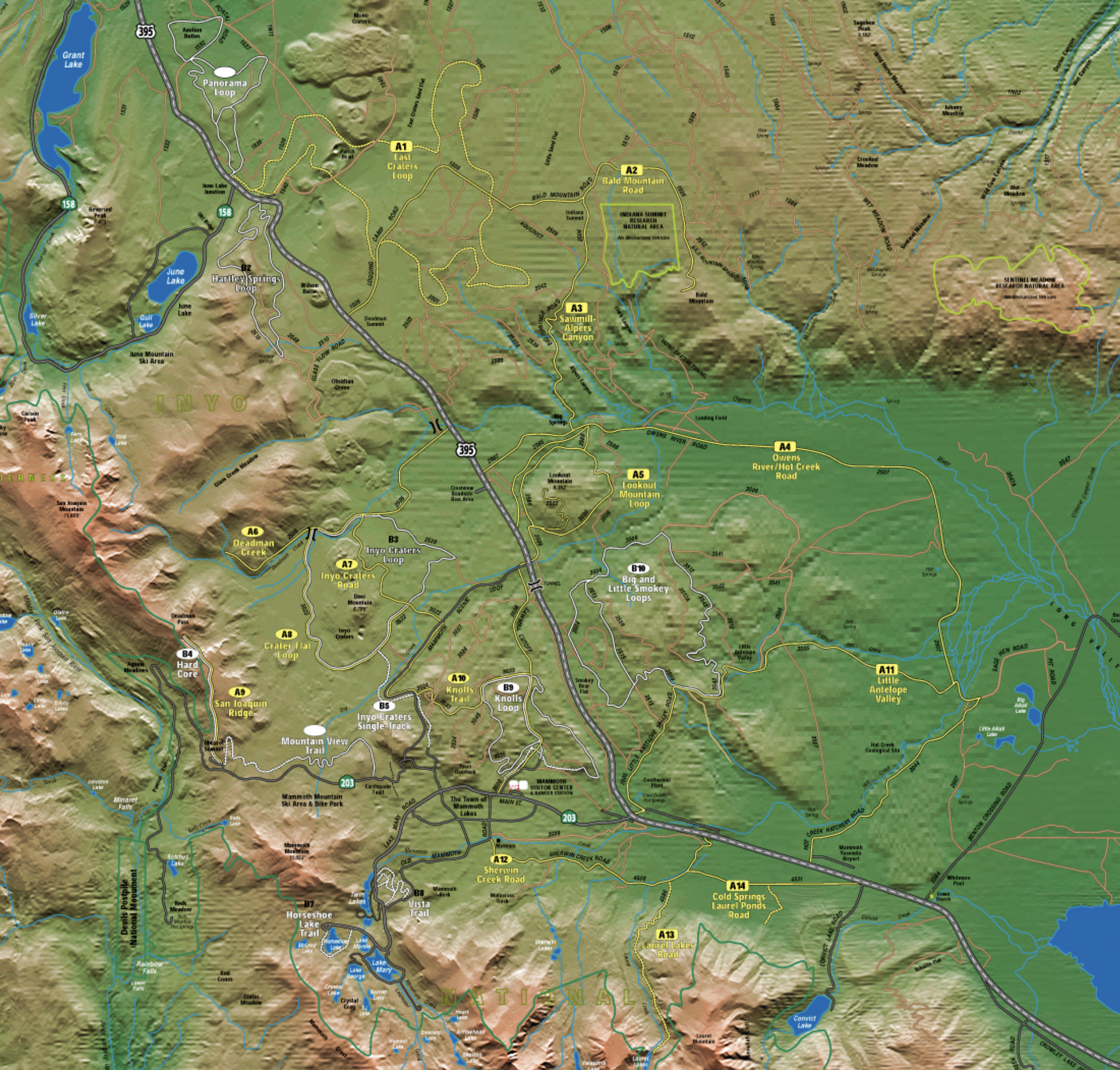
#10 Inyo Craters Single Track: This Trail is an old out-and-back OHV single-track, ridden since Mountain Biking came to Mammoth in the early 80s.
The Trail is a shared-use OHV trail that starts in the Mammoth Knolls Area, runs along the Mammoth Scenic Loop Road for a time, then crosses over the road and drops down into a thickly forested section before linking up with the Inyo Craters Loop. Surface conditions range from packed dirt to some soft pumice areas that you can mostly avoid if you watch for them.
The Inyo Crater single track is an out-and-back ride with a total estimated vertical rise of 1000 feet, a starting elevation of 7800 feet, and a peak elevation of around 8200 feet. You can use this out and back to link up with the Inyo Crater Loop for a 17.5-mile cross-country ride.
Directions: The ride starts about halfway up Mammoth Knolls Drive on an old, overgrown forest service road that was gated up in the late 80s. There is a second entrance to the Trail from the Uptown trail, where it meets the junction of Highway 203 and the Mammoth Scenic Loop.
About 2 miles in, the Trail does split off to the left at the junction of the Scenice Loop and the Forest Service Junction Road leading to the Mammoth Knolls area. At this junction, you also have the option to go straight on the OHV trail, but it’s very loose and soft and not advised. That section of the OHV trail goes down to the Inyo Craters Road Junction for those who want to take that route.
E-Bikes: Inyo Craters Single Track is OHV, so E-bikes are allowed, as are motorcycles, so be prepared.
Stats: Length – 7 miles of Out and Back Intermediate Riding – Link with the Inyo Craters Loop for a 17.5-mile ride – Elevations around 7800 – 8200 feet.
#12 Inyo Craters Loop Cross-Country Ride: This Route is a fun ride that loops 10.5 miles around the two Inyo Craters off the Mammoth Scenic Loop. There are some decent views on the ride of the two Inyo Craters and west toward Mammoth Mountain.
About half of this ride is in one of the world’s most extensive Jeffrey Pine forests. The number of trees and their great smell is abundant much of the time you’re on this route.
The route is a cross-country ride made up of 90% Forest Service road that goes through a mix of open areas and thick Forests. The dirt out on the loop is a combination of hard-packed, dusty loose dirt, firm single-track dirt, and some long sections with soft floating pumice.
There is a total ridable vertical rise of around 700 feet with a start elevation of 8100 feet and a low point in elevation of 7,700 feet.
I had some great rides on this route when the forest floor was moist over the years. There were some not-so-fun rides when it was dry, and you had to walk through the long sandy sections. The best way to ride through this loop is on a Fat Bike or an E-Bike with at least 3.0 tires on the back.
Directions: You can access the Inyo Crater Loop in two ways. The shorter route is to drive out the scenic loop and park at the Inyo Crater Trailhead.
Take a right at the Mammoth Scenic Loop, about 1 mile from town. Follow this paved road for about 2.6 miles to the Inyo Craters turnoff. Take a left and follow the signs to the Inyo Craters Trail Head parking lot.
Park at the trailhead parking lot (bathroom area at the lot). The mountain bike loop begins about a mile before the parking lot and heads west. There are Mountain Bike Trail Signs that mark the Trail.
For those wanting a long XC Ride, you can take the Knolls Trail from Shady Rest or the Scenic Loop Single Track Route from Mammoth Lakes to the Inyo Crater Single Track Trail. Also, if you ride this loop, do it during the morning hours as it gets hot in this area mid-day.
E-bikes: Yes, with the fattest tires you can put on your bike due to pumice and sand
Stats: Length – 10.5 miles – Effort Moderate – Elevations 7,700 – 8,150
#13 San Joaquin Ridge / Hard Core: This classic ride is a Hard Core Hill Climb at a high altitude. Only the fittest riders with the proper chain rings will want to tackle this. The dirt road route is a USFS Designated Mountain Bike and 4×4 route that covers 2.5 miles.
The out-and-back route offers excellent lung-busting views of the Ansel Adams Wilderness, Mammoth Mountain, Long Valley Caldera, and the Minarets. Be prepared for cooler temperatures and moderate to strong afternoon breezes. This is an excellent place to be on a hot summer day with the breezes that keep you cool.
Most hardcore people link this mountain bike ride with the Mountain View trail and then jump on Downtown on the way home to get back to town.
There is a total ridable vertical rise of around 1,000 feet with a start elevation of 9200 feet and a high point elevation of 10,220 feet.
Park in the dirt parking area almost immediately to your right. (Other websites say to park at the Vista; please park as we note here so the Vista lot is not filled up.)
Directions: To drive to the Trail, Take Minaret Road (Hwy 203) past the Mammoth Mountain Main Lodge Area. About 2 miles up the road, you turn right just before the Reds Meadow entrance station. The ride starts on the dirt road near the entrance station. You can also ride up the Mountain View Trail to access this ride.
E-Bikes: This Trail is an OHV route, so E-bikes are allowed.
Stats: Length – 5 miles out and back / Effort Very Strenuous Riding
#14 Big and Little Smokey Bear Loops: The Big Smokey Loop takes you on a climb into the adjacent hills, where the views, trees, and interesting reddish rock formations add to the ride’s aesthetics. This area also has many wooding operations you can see as you ride through. Keep safe and watch for the large firewood-hauling trucks you will see on this route.
The Little Smokey Loop offers a pleasant cruise through the local sagebrush, tall grasses, and wildflowers on the east side. Both routes contain a lot of loose sandy dirt, so you want to use a Fat Bike or E-Bike with large tires in this area. If not, you’re going to be miserable. Trust me, the first time I did this loop, it was not fun due to the heat and sandy-like dirt.
Directions: Drive North up 395 from Highway 203, about 5 miles, and you will see the large parking area with trail signs off to the right. This is just beyond the big Smokey Bear you see on 395. You can also access the Route from Saw Mill Road out of Shady Rest, take the tunnel you get to 395, and then head south 1 /2 mile to the Trailhead.
E-Bikes: These trails are an OHV route, so E-bikes are allowed and highly recommended. Make sure to have Fat Tires 3.0 if possible to prevent bogging.
Local Tip: Rent an E-Bike at Footloose and ride out Saw Mill Roda to the Loops for a long, fun ride. On the way back, you can hit the Mammoth Knolls Loop.
Stats: Length – 13 miles Big Smokey Loop / 6.1 miles Little Smokey Loop / Intermediate to Advanced / Long Sections of Soft dirt and sand go wide.
#15 Starkweather Trail: (Seasonal) This Trail is a fantastic adventure for expert mountain bikers. The route is all single track and starts with a downhill vertical ride of 1,100 feet, and then you turn around and climb back out. The downhill is full of fast-flowing twisting turns and is a fun fest.
The views here are beyond epic, with the Minarets and Banner Peak off in the distance. Along with the views, you get some nice forested and meadowy sections you go through.
This seasonal Trail is only open to Mountain Bikers when the Reds Meadow Shuttle is closed. Most years that leaves about two weeks in the spring and two weeks in the fall that you can ride down. ** Don’t even think of riding this Trail when it is closed; there is a hefty fine for doing so, and they can impound your bike if they want to.
There is a total ridable vertical rise of around 1100 feet with a start elevation of 9200 feet and a low point elevation of 8100 feet.
Most people have no idea this ride exists, and most people dislike the climb back out since it’s tough, so you won’t see anybody out here when the shuttle is not running.
If you’re in good shape, you can ride this Trail down into the valley, take the paved road to Reds Meadow, and then ride out. But beware, it’s a long uphill ride back to the vista point, so hydrate and eat, or you will bonk.
For the hearty and fit, I advise you to ride back up the Trail and forget the pavement. The first time I did this ride, we rode the pavement out, and it was dicey at times with all the cars so close to us, not to mention the fumes.
Directions: From Mammoth Lakes, take HWY 203 5 miles up and past the Mammoth Mountain Lodge and park at the Minaret Vista Entrance Station Dirt Parking area. The Trailhead is to the left of the Entrance Station.
Seasonal: Only open when the Reds Meadow Shuttle is closed, and no snow is on the ground.
E-Bikes: Stark Weather Trail is a non-motorized trail, so E-bikes are Not Allowed.
Stats: (seasonal) – Length Out and Back is 6.8 miles, 100% single track, Medium/Difficult technicality & Moderate to Difficult effort
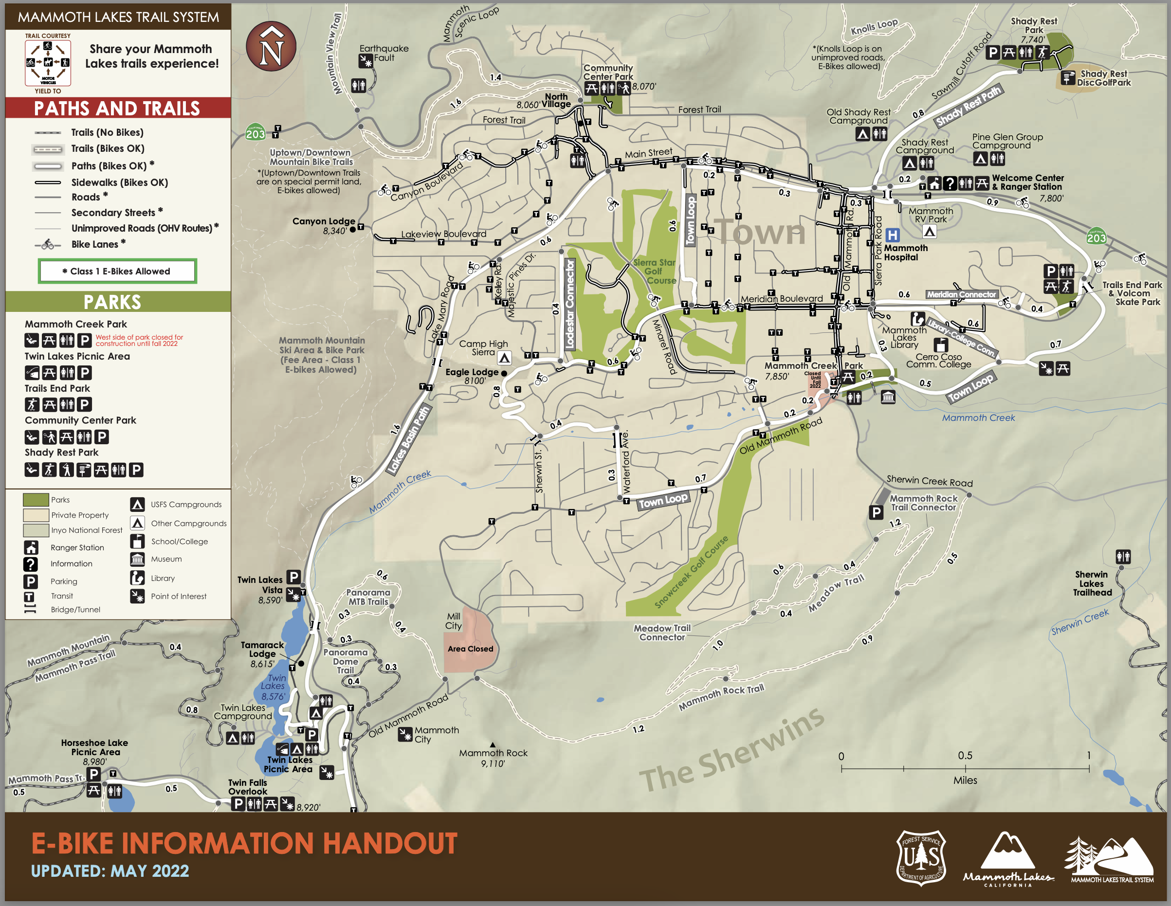
Mammoth Lakes Paved Bike Paths
The Mammoth Lakes Paved Trail System is one of the best assets the town has invested in over the last 20 years. This series of double-wide paved trails covers much of the Town of Mammoth Lakes and is a great place to ride your mountain bike out of the dirt.
Three main pathways are the Town Loop, the Lakes Basin Pathway, and the Shady Rest Path. You can ride from 7,500 feet to the 9,000-foot level, linking the Town Loop with the Lakes Basin Path.
I love to ride these paths, and they offer some great views and fast pavement to ride on. The networks of trails extend from Skate Park to Shady Rest Park to Town and up to Horseshoe Lake.
During peak Summer Vacation time, the Lakes Basin Path can have many people simultaneously spread out on the path. Slow down and pass people with caution.
E-Bikes: Yes, you can take your class 1 E-Bike on the Town Paved Trails
Mammoth Area Forest Service Road Rides
These roads can offer some great fun. All these forest service roads see a lot of 4 x 4 and truck traffic, and that can create soft and sandy sections.
The best time to ride on any of them is when it first melts out in the spring and then during the summer and fall seasons after moderate rains have moved through the area.
Most forest service roads within a few miles of town are not sandy, but there are a few sections to watch for.
The other good time to ride is after moderate to heavy Summer and Fall rains move through the area.
If you look at the Forest Service OHV Use Map, you will see miles of routes not listed below. So get out there, check it out, and see what you can come up with. Below are the roads I have ridden over the years.
Sawmill Road: This road comes from the lower part of town and the Shady Rest area. The road winds through the Forest for several miles before it comes out near the end of the Mammoth Scenic Loop, where it meets 395.
There is a tunnel at this junction that you can use to cross under 395 without worrying about high-speed traffic. The tunnel exit comes out right near the start of the Big and Little Smokey Bear loop rides and the road that will lead you to the ride up Bald Mountain.
E-bikes Are allowed on all Forest Service Roads, including Sawmill, the Smokey Loops, Bald Mountain Route, Laural Lakes Road, Sherwin Creek Road, and Mammoth Creek Road.
Mammoth Creek Road: This forest service road winds through the Forest from Old Mammoth Road down to the 395 and 203 highway junctions.
The road follows Mammoth Creek, and you can take small off-chute roads right to the creek in several places. About 1/2 way down, a bridge will allow you to cross over Mammoth Creek into the Sherwin Creek Campground.
The road winds down through the Jeffery Pine Forest about 800 vertical feet. Of course, that means it’s all uphill on your ride back into Mammoth Lakes, so be prepared with lots of water and carbs to fuel you back to town.
This is a fun dirt road to ride on, and it’s not a high-use area, so it’s an excellent place to go when the town gets crowded during peak summer weekends.
E-bikes Are allowed on this route.
Sherwin Creek Road: This out-and-back ride is on a forest service dirt road that will take you out past the Mammoth Moto Cross, the Sherwin Creek Campground and through some Jeffery Pine forests, and then into a vast open area that ends right at Highway 395.
Laurel Lake OHV Road Climb: This Trail has been washed out in sections for the last couple of years. You can still make it up on a good E-MTB; ensure you have a walking mode for the hike and bike sections.
There are a bunch of off-chute routes and trails you can ride here. Mid Summer, during the dry times, the road can get rutted severely along with a softer dusty surface. The best time to hang out here is early spring after a good rain.
Click Here for Mountain Bike Rides on the Inyo National Forest Outside of Mammoth
 Inyo Forest Mountain Bike Trails[/caption